Laboratory of Tree-Ring Research
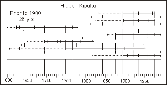
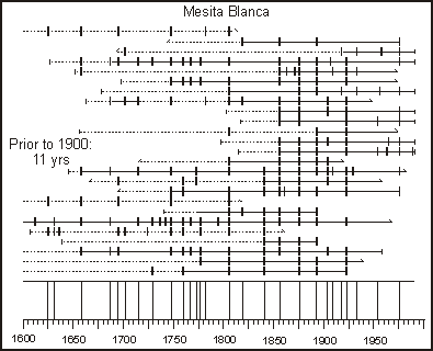
El Malpais, New Mexico Fire Graphs
How to read these fire graphs:
- Each long horizontal line represents one tree
- Each short vertical mark represents a crossdated fire scar
- The composite chronology at bottom shows vertical lines for years with at least two trees recording a fire scar
- The "Prior to 1900" number is average time interval between composite fires
These two fire graphs are quite different from the others of the Southwest:
- Fire frequency since 1900 is about the same as it was prior to 1900
- The reason for this is important and is explained in this article
- Grissino-Meyer, H.D. and T.W. Swetnam. 1997. Multi-century history of wildfire in the ponderosa pine forests of El Malpais National Monument. New Mexico Bureau of Mines & Mineral Resources 156:163-172. This paper describes the past and current fire patterns of sites within the lava flows of El Malpais, the badlands of New Mexico. (1.3-Mb pdf file, password protected)
Laboratory of Tree-Ring Research, University of Arizona
Tucson, Arizona 85721 USA
Main Office: (520) 621-1608, Fax: (520) 621-8229
Comments to Paul Sheppard: sheppard @ ltrr.arizona.edu
Copyright © 2000, Laboratory of Tree-Ring Research, University of Arizona
Revised April, 2000
URL: http://www.ltrr.arizona.edu/~sheppard/swland/elmalpais.html